I am very proud to present to you a joint project of Michael Holzapfel, Ramon Bauer and me: austromorph.space is dedicated to anamorphic maps of Austria. Anamorphic maps are maps in which the square area of a geographical feature is related to a thematic value. If for instance the areal size of municipalities is adjusted by their population, large cities, usually not much more than small dots in the map, would become more prominently represented, while rural communities with large are but few inhabitants would shrink.
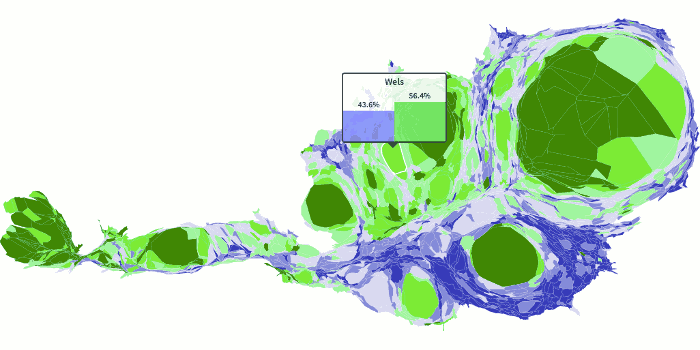
Our prime motivation are the preliminary maps of the results of the first round of the ongoing elections for the Austrian federal president. One candidate could win the support of mostly urban voters, the other one has a strong standing in rural areas. The maps TV, news papers and magazines showed, were suggesting a wrong image: Most of the country was painted in the colours of the candidate with rural support, the urban areas left a mere splotches of green in a sea of blue.
We resized the municipalities to represent their respective number of eligible voters, and –voìla!– the map looks a lot more balanced.
The maps are provided in a Creative Commons Attribution-ShareAlike 4.0 License, each individual map offers embedding code snippets. See an embedded map live in Ramon’s blog post “Austria, how blue can you go?”!
While we certainly will cover the second round of this election, we want to pick up the momentum and keep publishing maps on a more or less regular basis.
Update June 2016: As it seems we are continuing the election maps for a while longer. Stay tuned!